- Home
- ISLAMIC RESISTANCE
- SECRETARY-GENERAL
-
Full Speeches
- Speeches-2000
- Speeches-2006
- Speeches-2007
- Speeches-2008
- Speeches-2009
- Speeches-2010
- Speeches-2011
- Speeches-2012
- Speeches-2013
- Speeches-2014
- Speeches-2015
- Speeches-2016
- Speeches-2017
- Speeches-2018
- Speeches-2019
- Speeches-2020
- Speeches-2021
- Speeches-2022
- Speeches-2023
- Speeches-2024
- Speeches-2025
- Speeches-2026
- Speech-Reports
- SG
-
Full Speeches
- Voices
- Ten Day Dawn
- The Biggest Crime
- Martyr Leaders

UN Votes to Adopt New World Map that Shows Africa’s True Scale
By Staff, Agencies
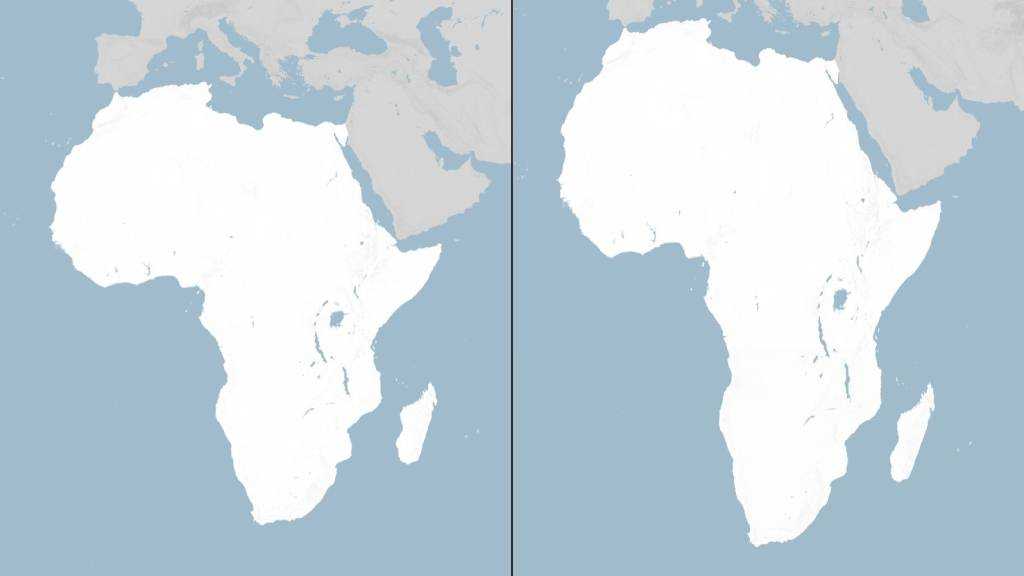
The United Nations has voted to adopt a resolution for the world to formally phase out the traditional Mercator map of the globe in favor of one that more accurately displays Africa’s size.
In a session at its headquarters in New York, the UN general assembly officially retired the 16th-century Mercator projection in favor of one based on the more accurate 2018 Equal Earth design.
At the session, 164 countries voted in favor of the resolution. Only the US voted no, with its representative saying the resolution was “superfluous”. There were six abstentions.
UN resolutions are non-enforceable, so countries and institutions will not be mandated to use only the new projection or forbidden from using the old one. However, the outcome is expected to result in an update of classroom curriculums and everyday technology given the wide usage of the Mercator projection in education, technology and governance.
Drawing of Mercator with a globe and compass in his hands. He wears a beret-style hat and has a long reddish beard.
Togo, which spearheaded a campaign for the resolution on behalf of the African Union, said the resolution “recognizes and affirms that disproportionate cartographic representations, particularly those resulting from the Mercator projection, have had lasting cognitive, educational, cultural, geopolitical and socioeconomic effects, contributing to a drastic reduction in the perceived size of Africa and other regions of the world in the global collective imagination”.
Speaking before the resolution passed, Robert Dussey, Togo’s foreign affairs minister, said: “This discussion is not a political discussion [but] a scientific discussion, because there is scientific proof so we all have to accept the reality.”
The Mercator layout was introduced by the Flemish cartographer Gerardus Mercator in 1569 to help sailors navigate the seas. Almost five centuries later, it remains the global standard.
Because of its projection style, however, regions near the equator appear significantly smaller than they are, whereas high-latitude areas look much larger. For example, the map shows Africa as being similar in size to Greenland, but the continent is 14 times larger than the Danish territory.
“You could fit the United States, China, India, Japan, Mexico and much of Europe into Africa and still have land to spare,” says a petition on Change.org for the #CorrectTheMap campaign, which has more than 11,000 signatures. The African Union endorsed the campaign in August 2025 and then asked Togo to spearhead its adoption.
On Friday, before the vote, France’s foreign minister spoke in support of the resolution.
Historians and geographers have said for years that the Mercator projection is rooted in western stereotypes. Activists have echoed this, with some coining the term “cartographic colonialism”.
Comments
- Related News